|
 |
|
Old Town Maps
View old maps of British towns and cities. Access
hundreds of old maps, focussing on the towns and cities of Great
Britain as they were around the middle of the twentieth century.
The maps shown are derived from the revised half inch contoured
map series of Great Britain produced by John Bartholomew & Son
Ltd of Edinburgh throughout the last century. See map detail of
the cities, towns and villages of England, Scotland and Wales as
they were then, captured in the maps of the time.
The navigation links above,
indexing the old town maps alphabetically by country, allow free
access to hundreds of old town maps throughout Great Britain.
Large scale maps, extracted from Bartholomew's reduced survey
maps of the period, are centred on the towns, showing the extent
of the built up areas, classified roads, railways and other
geographical detail of the surrounding areas.
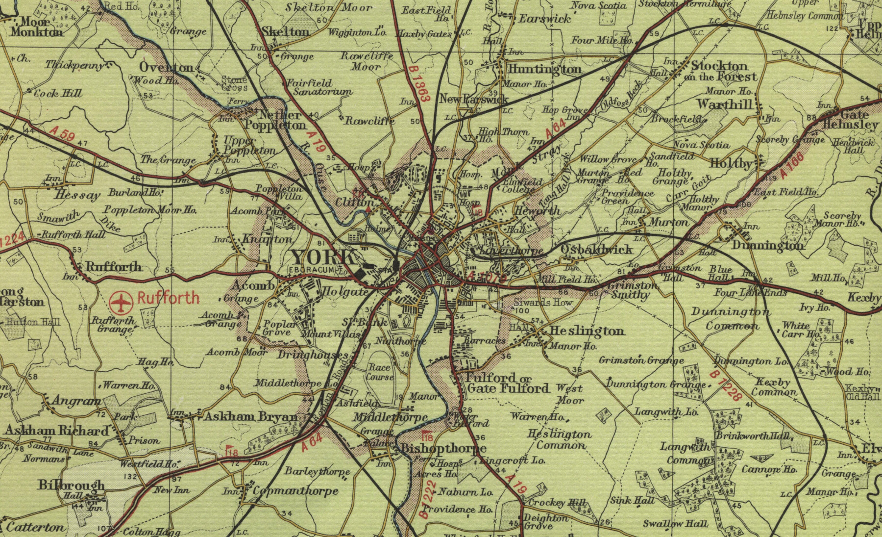
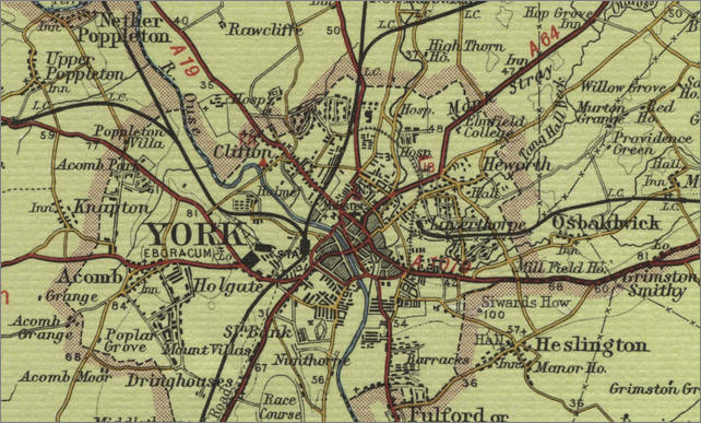
All the
old town maps may be viewed at the click of a mouse. To
see an example, click on the map of York on the right.
|
 |
|
Old
Maps of British Towns
Great changes have taken place in the
British landscape since the middle of the last century, in city and
townscape, in road and rail links, in the land used for houses and new
industries, changes reflected in the maps of each period and most
evident when comparing the old town maps with the maps of today. If you travel
through the British countryside today, you are likely to see
very different scenery from that shown on the old mid twentieth century
town maps shown here. The beautiful
English, Scottish and Welsh natural landscape of wild mountain and moor
will be much the same, as will the picturesque hills and dales, the rivers and
lochs, the remote western islands, the rich farmland. The geography of
the long and varied British sea
coast will not have changed a great deal. It is in the historic cities, towns and
villages of England, Scotland and Wales where the change of scenery will
be most marked; in the human landscape of houses, shops, roads, railways,
seaports, airports and industry; in the character of the great English,
Scottish and Welsh cities,
of the popular coastal holiday resorts and busy summer tourist centres,
the bustling market towns and the quiet, sleepy rural villages. Many of
Britain's towns and villages have seen great growth in recent times, in
new accommodation, homes for an increasingly affluent population,
improved transport and communications and new industries to replace the
old. Such history is reflected in the maps on this website, old maps which show
British cities, towns and villages, and the surrounding countryside, as
they were half a century ago and the historical detail of city and town,
road and rail, are recorded on the old town maps. Although many
places of scenic and historic interest, particularly those famous old
towns, cities and villages, full of interesting history and character,
have been conserved, the visitor planning a trip to England, Scotland or
Wales is likely to find a very different landscape from that shown on
the old maps. The maps on this website, made not long after the Second
World War, may provide useful information for those interested in
genealogy, family history or the recent history of British towns.
|
|
Background to Old Town Maps
Bartholomew's
Half-Inch Maps (scale 1:126,720 ) were published,
with variations in format and titling, from 1875
through to 1999, at the Edinburgh Geographical
Institute. The Revised Half-Inch map series, from
which the old town maps on this website are derived,
were published, with frequent revisions, from 1921
until 1974. The series consisted of 62 maps sheets
covering the whole of Great Britain. The series was
aimed mainly at those involved in recreational
pursuits, such as cycling and motor touring, and
were extremely popular throughout the last century.
Reduced Ordnance Survey Maps
Bartholomew's half-inch
maps were based on the more detailed
Ordnance Survey mapping on the one-inch
to the mile scale (1:63,360). The firm
had earlier published 'Reduced
Survey Maps' of Scotland, England and
Wales. The new "Revised" series were
progressively revised and updated
throughout their publication. The maps
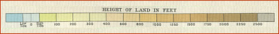
were distinctive in their innovative use
of colour layering, i.e. using different
layers of colour to represent land
relief. A subtle and innovative
graduation of colour bands was employed
for land at different heights - lighter
greens for low ground closest to
sea-level, darker greens and browns for
higher ground, with white used for
mountain summits.
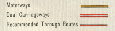
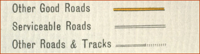
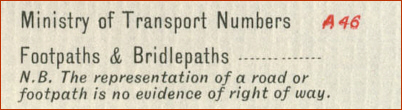
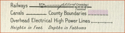
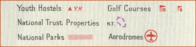
Key to Old
Town Maps
In the Revised
Half-Inch map series, the
land is contoured according to
altitude and County boundaries, Golf
Courses, Youth Hostels, National Trust
Properties, etc., clearly marked. Roads
are classified and Ministry of Transport
numbering is shown. The map key below
shows the meaning of the major symbols,
representing the features above and
others such as roads, railway lines,
canals etc. used on the half inch map
series, extracts of which are reproduced
on this website by kind permission of
Collins Bartholomew.
|
|
|